ARGENTINA
1. GENERAL INFORMATION
1.1. General Overview
1.1.1 General geographic information
Main territory of Argentina is located in continental South America, bounded by Bolivia and Paraguay on the north; by Brazil, Uruguay, and the South Atlantic Ocean on the east; by the South Atlantic Ocean and Chile on the south; and by Chile on the west. Another significant territory has been historically claimed by Argentina on several island groups in the South Atlantic Ocean, including the "Malvinas" (Falkland), and in Antartica, representing a total of approx. 970.000 km2. Considering only the continental territory in South America strechting between the Bolivian border (at 21º South Lat.) and the extreme south of Tierra del Fuego (at 55º South Lat.), the north to south length of Argentina is 3 799 km; its extreme width is 1 423 km; and its area is 2.791.810 km2. Argentina is the second largest South American country; its borders with other countries amount to 9 376 km and its total coastline on the South Atlantic Ocean (including islands) measures 4 725 km in length.
Argentina has a diverse territory of mountains, upland areas, and large plains. The western boundary of the country is within the Andes mountain system. Eastward from the base of the Andean system, the terrain of Argentina is almost entirely flat or gently undulating plain. The Pampas, treeless plains that include the most productive agricultural sections of the country, extend nearly 1,600 km south from Chaco (northern forests) and north from Patagonia. In Patagonia, southern territory of continental Argentina with nearly one million km2, the terrain is largely arid, with desolate steppes. Sources for geographic data : "Instituto Nacional de Estadísticas y Censos" (INDEC, Federal Institute for Statistics and Census. www.indec.gov.ar), "Instituto Geográfico Militar" (IGM, Geographic institute of the Army. www.igm.gov.ar), "Servicio de Hidrografía Naval" (SHN, Hydrographic Service of the Navy. www.hidro.gov.ar). Additional information on geographic data can be obtained at their sites.
Temperate weather conditions prevail throughout most of Argentina, except for a small tropical area in the north-east and the subtropical Chaco region in the north, as well as colder areas in southern Patagonia including Tierra del Fuego and other islands in the South Atlantic Ocean. Near Buenos Aires the average annual temperature is a mild 16.1 °C. January and July averages for this area are 23.3 °C and 9.4 °C, respectively. Considerably higher temperatures prevail near the tropic of Capricorn in the north. The annual average temperature in this region is 23.3 °C with extremes as high as 45 °C. Weather is generally cold in Patagonia and Tierra del Fuego. In the western section of Patagonia, corresponding to the Patagonian Andes, winter temperatures average about 0 °C. In most coastal areas, however, the ocean exerts a moderating influence on temperatures.
Precipitation in Argentina has wide regional variations: south and west are semiarid, but the extreme north gets more than 152 cm of rainfall annually. Near Buenos Aires annual rainfall is about 102 cm. Additional information on climate data can be obtained at the site of the "Servicio Meteorologico Nacional" (SMN, National Meteorological Service), www.meteonet.gov.ar
1.1.2 Population
Argentina is constituted by 23 provinces and the self-governing Federal District of Buenos Aires. According to the Federal Constitution (amended in 1994), Argentina is a federal republic headed by a president, assisted by ministers and secretaries, which constitute the "Executive" branch of the Federal Government. The other two branches of it are the "Legislative" one (or "National Congress" comprising two chambers, namely the Senate and the Chamber of Representatives) and the "Justice" branch, headed by the Nation´s Supreme Court.
In 2002, Argentina's population was estimated at approx. 38. million of which about 89% lived in urban areas, see Table 1 for the historical population data. More than one-third of the population lives in or around of Buenos Aires, the capital and the largest city, with a population of 11 460 000 including its suburban area. Other important cities are Córdoba (metropolitan area population of 1 180 000), a major manufacturing and university city; the river port of Rosario (metropolitan area population of 1 160 000); Mendoza (metropolitan area population of 780 000); Tucumán (population 625 000); Mar del Plata (520 000)
Source of population data : "Instituto Nacional de Estadísticas y Censos" (INDEC, Federal Institute for Statistics and Census). Additional information on population data can be obtained at its site: www.indec.gov.ar
TABLE 1. POPULATION INFORMATION
|
|
|
|
|
|
|
|
|
Growth |
|
|
|
|
|
|
|
|
|
rate (%) |
|
|
|
|
|
|
|
|
|
1990 |
|
|
|
1970 |
1980 |
1990 |
2000 |
2001 |
2002 |
To |
|
|
|
|
|
|
|
|
|
2002 |
|
|
||||||||
|
Population (millions) |
|
24.0 |
28.1 |
32.5 |
37.1 |
37.5 |
38.0 |
1.3 |
|
Population density (inhabitants/km²) |
8.7 |
10.2 |
11.8 |
13.4 |
13.6 |
13.7 |
|
|
|
|
|
|
|
|
|
|
|
|
|
Predicted population growth rate (%) 2002 to 2010 |
9.1 |
|
|
|
|
|||
|
Area (1000 km²) |
2791.8 |
|
|
|
|
|||
|
Urban population in 2002 as percent of total |
88.5 |
|
|
|
|
|||
Source: IAEA Energy and Economic Database, Country Information.
1.1.3 Economic Indicators
Table 2 shows the Gross Domestic Product (GDP), GDP per capita, their growth rates and the GDP by sector.
TABLE 2. GROSS DOMESTIC PRODUCT (GDP)
|
|
1995 |
1996 |
1997 |
1998 |
1999 |
2000 |
2001 |
|
GDP at market prices ( billion current US$) |
258 |
272 |
293 |
298 |
283 |
281 |
269 |
|
GDP growth (annual %) |
-2.85 |
5.53 |
8.11 |
3.88 |
-3.21 |
|
|
|
Agriculture, value added (% of GDP) |
5.7 |
6 |
5.6 |
5.71 |
4.64 |
|
|
|
Industry, value added (% of GDP) |
28 |
28.42 |
29.15 |
28.69 |
28.24 |
|
|
|
Services, etc., value added (% of GDP) |
66.3 |
65.58 |
65.25 |
65.6 |
67.12 |
|
|
Source: Data & Statistics/The World Bank, Country Information
1.1.4 Primary Energy Situation
Most rivers and waterfalls with potential energy are far from the industrial centres, but despite these limitations water resources have been widely developed in Argentina (hydraulic resource potential is 1,926,000 TJ). Major hydroelectric projects undertaken in the 1970's and 1980's are in the northern Patagonia (Chocon, Cerros Colorados, Piedra del Aguila, etc.), on the Paraná River (Yacireta, a joint project with Paraguay), and on the Uruguay River (Salto Grande, in co-operation with Uruguay).
Although the country has a variety of mineral deposits (only one fifth of the country has been surveyed), mining has been relatively unimportant, contributing only 0.2% to Gross Domestic Product (GDP). Since the gas and petroleum sector privatization, exploration for hydrocarbons has increased significantly. Proven natural gas reserves amount to 579 million metric tons. Coal reserves in Argentina are limited: lignite deposits are estimated at 195 million t and peat at 90 million t.
Argentina has moderate uranium resources (proven reserves of 5 240 tn and additional estimated resources of 2400 tn). Source : National Atomic Energy Commission (CNEA)
Table 3 shows total energy resources. Table 4 shows the energy statistics
TABLE 3. ESTIMATED ENERGY RESERVES
|
|
Estimated energy reserves in 1999 |
|||||
|
|
(Exajoule) |
|||||
|
|
|
|
|
|
|
|
|
|
Solid |
Liquid |
Gas |
Uranium |
Hydro |
Total |
|
|
|
|
|
|
|
|
|
|
|
|
|
|
|
|
|
Total amount in place |
3.37 |
16.28 |
24.23 |
4.8 |
51.57 |
100.25 |
|
|
|
|
|
|
|
|
Source: Country Information
1.2. Energy Policy
As a result of governmental policies during the three decades of 1960´s, 70´s and 80´s the electricity sector has been characterized by:
· Diversification of energy source technologies:The utilization of hydroelectric resources and the development of nuclear technology have reduced the share of fossil fuels to 42% of the total in 1994 relative to 93% in 1972. However, during the 1990´s decade the increases in the total installed capacity came mainly from:
Ø Completion of the remaining
large hydro-electric capabilities;
Ø Additional capacity
was fulfilled mainly through the erection of new combined cycle gas turbine
plants.
TABLE 4. ENERGY STATISTICS
Exajoule
|
|
|
|
|
|
|
|
Average annual |
|
|
|
|
|
|
|
|
|
growth rate (%) |
|
|
|
|
|
|
|
|
|
1970 |
1990 |
|
|
1970 |
1980 |
1990 |
2000 |
2001 |
2002 |
To |
To |
|
|
|
|
|
|
|
|
1990 |
2002 |
|
|
|
|
|
|
|
|
|
|
|
Energy consumption |
|
|
|
|
|
|
|
|
|
- Total (1) |
1.26 |
1.77 |
2.05 |
2.82 |
2.91 |
2.99 |
2.48 |
3.17 |
|
- Solids (2) |
0.10 |
0.11 |
0.09 |
0.04 |
0.03 |
0.03 |
-0.71 |
-8.71 |
|
-
Liquids |
0.94 |
1.10 |
0.84 |
1.02 |
1.03 |
1.05 |
-0.52 |
1.82 |
|
- Gases |
0.21 |
0.40 |
0.88 |
1.42 |
1.49 |
1.56 |
7.44 |
4.91 |
|
- Primary electricity (3) |
0.01 |
0.17 |
0.25 |
0.35 |
0.36 |
0.35 |
15.06 |
2.94 |
|
Energy production |
|
|
|
|
|
|
|
|
|
- Total |
1.15 |
1.66 |
2.18 |
3.66 |
3.82 |
4.04 |
3.25 |
5.29 |
|
- Solids |
0.08 |
0.08 |
0.06 |
0.02 |
0.02 |
0.02 |
-1.42 |
-9.69 |
|
- Liquids |
0.85 |
1.08 |
1.09 |
1.73 |
1.72 |
1.79 |
1.25 |
4.23 |
|
- Gases |
0.21 |
0.33 |
0.79 |
1.58 |
1.73 |
1.90 |
6.90 |
7.57 |
|
- Primary electricity (3) |
0.01 |
0.17 |
0.24 |
0.33 |
0.34 |
0.33 |
14.84 |
2.82 |
|
Net import (Import - Export) |
|
|
|
|
|
|
|
|
|
- Total |
0.12 |
0.14 |
-0.11 |
-0.84 |
-1.05 |
-1.57 |
0.60 |
24.89 |
|
- Solids |
0.02 |
0.02 |
0.03 |
0.01 |
-0.02 |
-0.22 |
0.60 |
-19.56 |
|
- Liquids |
0.10 |
0.05 |
-0.22 |
-0.70 |
-0.69 |
-0.65 |
-3.97 |
9.51 |
|
- Gases |
|
0.07 |
0.09 |
-0.16 |
-0.34 |
-0.71 |
|
-19.26 |
|
|
|
|
|
|
|
|
|
|
|
|
|
|
|
|
|
|
|
|
|
(1) Energy consumption = Primary energy
consumption + Net import (Import - Export) of secondary energy. |
|
|
||||||
|
(2) Solid fuels include coal, lignite
and commercial wood. |
|
|
|
|
|
|
||
|
(3) Primary electricity = Hydro + Geothermal
+ Nuclear + Wind. |
|
|
|
|
|
|||
|
(*) Energy values are in Exajoule except
where indicated. |
|
|
|
|
|
|
||
Source: IAEA Energy and Economic Database, Country Information.
As a result, and accompanying an average annual growth in the total electricity generation of around 7 % in the period 1991-1997 and a progressive decline in the following years 1998-2001 (Argentina´s economic depression and crisis), the thermal share increased again during the last decade with a normal value of around 52 - 55%. The main exception occurred in 2001 when the combination of extensive heavy rains and electricity demand reduction led to an unsual hydro-power share of 55 % together with a thermal share of only 37 %.
· Reduced consumption of oil
in thermal power stations: Current oil consumption (1,440,000 toe in 1990) is
comparable to that of the early 50s, even though power generated by thermal
stations has increased fivefold - as a result of intensive use of natural gas.
· Nation-wide electric transmission
and distribution system: Electrification index is 95%
in urban areas and above 86% at the national level.
· Low participation of self-generation
in Argentinas supply of electricity: Currently self-generation
accounts for only 11% of electricity generation relative to 20% in the late
1960s.
· A highly integrated interconnected system.
· Initiation of electric energy exports to Brazil in spite of different
frequency systems (50 Hz in Argentina and 60 Hz in Brazil).
It is important to underline that during the three decades of 1960´s, 70´s and 80´s the overall energy policy was almost exclusively dictated by the Federal Government, with emphasis on planning, diversification and balanced / optimal use of the various types of national energy resources both in the short and long term.
At the opposite, during the 1990´s decade a fully deregulated market was designed and implemented in all the energy activities. This led in particular to a concentration and increasing use of natural gas, especially for electricity generation through new CCGT plants, that is the present cheapest option.
In the first case, special cares and rules were established in order to avoid a rather fast extinction of national oil and gas resources, giving maximum priority to the construction of all major hydraulic power stations feasible to be built both in plain and mountain rivers. In the second case, there was a fast expansion both in demand and capacities, though all the capacity expansions were no more subject to a coordinated planning and balanced use of the different national resources, but led to a systematic market-profit selection of the cheapest option : the sustained use of the national natural gas. In the very last period, 2001-2002, the economic recession and financial crisis, paralyzed any new project for expanding the generation capacity.
The large national reserves of oil and gas, together with the operating large hydro-power stations provide the country with a sustancial capability for energy exports, mainly in the form of gas pipe-lines and electricity HV lines. With different accents this capability has been developed during the last decade towards the neighboring countries, namely Brazil and Chile.
Finally, it must be mentioned that the effects of GHG emissions and climate change, including the Kyoto Agreement, had up to now no effects on the overall energy policies. This is a result of the combination of the fully deregulated energy markets presently ruling in the country, and the rather low population spreaded on a very large territory
1.3 The Electricity System
1.3.1. Background and Structure of the Electricity Sector
In the forties Argentina began establishing state-owned energy companies, nationalizing foreign owned energy utilities and defining energy plans to fully integrate the national planning scheme. The plans used advanced planning methodologies and considered the integration of electricity within the global energy system. Plans were mainly promulgated by the Secretary of Energy and agencies in charge of global economic planning with the participation of national public energy companies.
Despite the political instability and the successive changes in the economic and institutional policies, the plans designed by the state owned energy companies transformed the electricity system. The electricity system expanded significantly since 1970 when it covered 54% of the population to today's 90% of the population. An interconnected electrical grid system now supplies 90% of the country's requirements. Domestic energy resources are utilized, particularly renewable sources, thus diversifying the mix of primary energy sources.
In 1980's the country's economical crisis, together with a burdensome foreign
debt, resulted in critical conditions for the electricity system. At the same
time, institutional decentralization led to the proliferation of many provincial
electricity distribution and production companies, and to the dispersion of
tariffs and economic regulations within the electricity system. Later, due to
State reform initiated in 1990, the institutional structure and regulation of
all energy-related activities underwent substantial modifications. The energy
policy was based on a free market economy bolstered by private sector investments
in the energy system.
Materialization of this policy began with privatization of Servicios Eléctricos
Gran Buenos Aires (SEGBA), along with Agua y Energía's hydro and fossil
fuel stations, hydropower stations owned by Hidronor, and the Sistema Interconectado
Nacional (high voltage transmission network).
From the organizational point of view, Argentina's electricity sector shows
a historical development similar to that of most European and Latin American
countries. Since its origins until after the World War II, electricity supply
was in private hands, subject to the control of local authorities who granted
operation licenses and developed franchises within their respective jurisdictions.
State companies involved in the supply of electricity have grown since 1945
and in 1990 they owned 84% of Argentina's generating capacity.
In the mid 1960's a decentralization process began with the creation of state-owned
generating companies. Decentralization was further intensified in 1980 with
the transfer of distribution networks from one of the state companies, Agua
y Energía, to the provincial governments. This decision from central
administration encouraged the creation of new provincial agencies and made regulation
more complex.
The federal government kept the primary responsibility for planning expansions
in electricity generation and high voltage transmission. Six state agencies
were responsible for the construction and operation of the facilities. Decentralized
power generation led to a significant wholesale electricity market regulated
by the federal government through the Load Dispatching Centre (Despacho Nacional
de Cargas).
Electricity distribution to end-users was carried out by more than 600 organizations:
two state companies (supplying 55% of electricity consumption nation-wide),
21 provincial companies (34% of consumption) and some 580 co-operatives (11%
of consumption). Provincial companies can only operate within the boundaries
of their respective provinces, while co-operatives can provide services in municipal
areas. The right of provincial and municipal regulators to determine the end-users'
electricity tariffs and their independence to fix taxes on electricity consumption
within their jurisdictions led to a great price discrepancy among users with
similar consumption patterns.
Institutional changes and a stiff regulatory framework impaired the performance
of the electricity sector before the sector reform. Efficiency of state-owned
utilities was affected by politically fixed low tariffs and indebtedness in
recent years, which lead to supply crisis. The most noticeable signs in the
technical phase were the unavailability of thermal generating equipment which
necessitated streamlined electricity consumption in 1988/89 under conditions
of low water inflows; increase in distribution losses up to 23% of sales; and
construction delays which increased average fuel consumption through expanded
use of gas turbines.
At the beginning of the 1990´s the new Federal Government introduced sustantial
changes to the organization, regulation, and the ownership of electricity companies
including the privatization of most facilities owned by SEGBA, Hidronor and
Agua y Energía. Before the reform, electricity was supplied by a number
of utilities with different legal standings and functional dependencies, although
state agencies controlled 99% of the installed generating capacity.
Reorganization of Argentina's electricity sector, both on institutional and
regulatory levels, was realized upon the approval of Law 24,065 of January 1992,
which sanctioned the transfer of facilities to private hands through the privatization
process begun in May 1992.
The new legal framework has organizational and regulatory impacts on the activities
that are carried out under national jurisdiction, since the provinces have only
partially joined the national framework. Despite of the diversity of regulatory
jurisdictions, the fact that the state companies dominated electricity generation
and transmission systems before the reform has assured national jurisdiction
over these industry segments that are central to the wholesale electricity market.
Between April 1992 and April 1995, 9830 MW(e) of installed capacity held by
SEGBA (2,480 MW(e)), Agua y Energía (2,800 MW(e)) and Hidronor (4,290
MW(e)) were transferred to private operators. Of the above capacity, 37% is
fossil fuel fired steam turbines; 15% gas turbines and the remaining 48% hydro
stations.
Provincial jurisdiction covers primarily electricity distribution, which is
carried out largely by provincial companies who buy electricity at the wholesale
market. Provincial companies who own power stations are subject to national
rules for the operation of the system if they use transmission lines or sell
their excess generation in the wholesale market. The new regulatory regime covers
the electricity industry where institutional organization and ownership patterns
differ from regulations that were in effect until the late 1991. Horizontal
and vertical partitioning of national companies was assumed to encourage competition
and to promote efficiency. The objectives of these changes, inspired to a large
extent by the reforms in Great Britain, are to protect users' rights; promote
market competitiveness; encourage private investment for long term supply; promote
reliable operation and free access to service; regulate transmission and distribution
and assure reasonable tariffs.
Participants in the electricity sector are:
i) producers, whether independent, national, bi-national or provincial, and
interconnected foreign electric utilities;
ii) distributors, large consumers and interconnected foreign electric utilities;
iii) transmission companies;
iv) regulatory agencies: The Electricity Regulator (Ente Nacional Regulador
de la Electricidad, ENRE) and the Wholesale Electricity Market
Administrator (Compañía Administradora del Mercado Mayorista Eléctrico, CAMMESA).
Participants in each class are semi-autonomous, that is, they have limited influence
outside their individual areas. The independence of transmission companies ensures
free electrical grid access to third parties. Distributors have to provide for
the excess electricity if they have spare capacity. Any party authorized by
the Secretary of Energy to participate in the wholesale electricity market must
abide by the prescribed market rules. Because of their monopolistic characteristics,
power transmission and distribution systems are regulated and require granted
concessions. Grid expansions are subject to market mechanisms.
Producers are subject to concessions only if they operate hydroelectric power
stations. Installation of thermal power stations requires authorization for
grid connection and compliance with applicable public safety and environmental
protection regulations. CAMMESA supervises the whole production system that
works in a Fully Deregulated Market. In so doing, CAMMESA selects and authorizes
at any moment every new additional input to the national grid among the different
producers according to the plant "marginal cost" (additional cost
while in operation, i.e. mainly the fuel cost) : that non-operating but available
plant having the lowest marginal cost is selected for providing any new required
additional capacity to the national grid. Accordingly, excess capacity is removed
from the grid selecting that plant having the highest marginal cost. In this
way, minimization of total and average electricity generation cost is assured.
Distribution is largely in the hands of provincial utilities and co-operatives
(65%) due to privatization of Agua y Energía and the transfer of its
services. Of the distribution systems held by state companies, only the service
in the concession area of the former SEGBA is in private hands, where now three
private distribution companies are supplying 35% of the retail electricity market.
Prior to April 1995 only one provincial distribution company Empresa de Distribucion
de Energia de Salta (EDESAL), had been privatized, although several provinces
had announced interest to privatize their services and were in process of adjusting
the provincial regulatory framework to allow private electricity operators inside
their jurisdictions. The role of CAMMESA is that of a wholesale electricity
market administrator in commercial agreements between parties (forward contracts).
General supervision and regulation of the industry under national jurisdiction
is in the hands of ENRE (Ente Nacional Regulador de la Electricidad), chartered
as an independent agency within the Secretary of Energy. ENRE's main duties
are:
i) enforcement of concession contracts;
ii) prevention of anti-competitive, monopolistic or discriminatory behaviour;
iii) participation to the selection of concession holders;
iv) organization and implementation of public hearings to clarify conflicts
between parties;
v) environmental protection and public safety issues associated to the electricity
sector.
ENRE supervises national distribution companies and settles disputes between parties as long as they operate under the national jurisdiction. The office of the Energy Secretary is the national agency, which interacts with provincial governments in matters relating to the electricity supply industry.
All electricity supplied to the interconnected electrical system is commercialized
through the wholesale electricity market. This market includes a contract market
and a spot market.
The end user market is also divided into a regulated and a non-regulated segment.
The non-regulated segment is open to competition among bidders, particularly
large consumers. The minimum consumption threshold to access the wholesale electricity
market was initially 5 MW(e), but it has now been reduced to 1 MW(e). Access
thresholds must be authorized by ENRE.
Differences between outlays that state owned producers should have invoiced
according to prevailing spot prices and the receipts actually received are assigned
to Unified Fund for debt servicing and to fund investments for the completion
of any construction in progress at the time of the reform.
1.3.2 Policy and Decision Making Process
Privatization of state companies was implemented to encourage market competition.
For this purpose, separation of generation, transmission, and distribution systems
was established. Within this framework, the Energy Secretary is responsible
for:
i) defining the policies for the electricity sector;
ii) licensing newcomers to the wholesale electricity market;
iii) establishing the rules with which the electricity supply industry must
comply;
iv) authorizing the allocation of funds to state companies;
v) deciding on the respective awards during the privatization process.
In order to attend to the technical management of the system and to administer the wholesale electricity market, Load Dispatching Centre became a stock corporation, CAMMESA, with an equity interest held by the Secretary of Energy and by different utilities in the wholesale market. The Secretary of Energy may reduce its capital share in CAMMESA to 10%, and still retain the power of veto to Board decisions. CAMMESA is the electricity system's technical authority.
Presently, Argentina plans to develop an integrated resource planning and decision-making
process aimed at co-ordinating the functions of its diverse institutional system
and assuring thorough participation of all sectors, public and private. Mechanisms
related to the electrical system expansion, economic management and regulation
with mitigating impact on the environment have not been defined.
In accordance with constitutional principles, riverside provinces own the water
resources utilized by the hydroelectric companies. The provinces grant licenses
for commercial operation, even though existing facilities belong to the Federal
State, and collect generation royalties. Provincial governments also authorize
the construction of new projects in their respective territories, provided that
the new companies do not join the wholesale electricity market through business
transactions or through transmission or distribution networks under national
jurisdiction.
In the regulated segment, a distributor is assured a monopoly and has to meet
the required electrical demand pursuant to the terms of the concession contract.
If no private investors are interested in distributing electricity to certain
areas, then the State has the obligation to supply the service there.
Concession contracts specify technical and commercial quality of service which
concession holders are obligated to provide. The obligations of the company
are not subject to electricity availability in the wholesale market, and the
State takes no commitment to solve potential power shortages.
The tariffs in this market segment cover all distribution costs (network expansion, operation and maintenance, marketing and the cost of purchasing electricity in the wholesale market) including a rate of return fixed by ENRE. In the future, wholesale spot price variations will be passed by distributors directly to customers.
Everyone in the wholesale electricity market participates directly or indirectly
in the spot market. The operation of this market is managed by CAMMESA. The
operation of interconnected generating units is scheduled by CAMMESA for six
month seasonal periods to cover demand forecasts with the reserve agreed between
the parties (economic load dispatching). The average seasonal marginal cost
is the base price from which the price to the distributors is calculated. Distributors
pay a differential price depending on their location in the system, which reflects
their contribution to transmission losses.
Distributors also pay a fixed charge for their average estimated demand for
power over the next five years. The risk associated with this estimate is borne
by the distributors who must assume the payments in the event of overestimation
of demand and are penalized in the event of underestimation. In addition, distributors
contribute toward CAMMESA's expenses by paying a fixed connection charge and
a transmission capacity charge to transmission companies. Electricity suppliers
are compensated for:
i) the energy supplied by a plant run according to schedule, at the system's
marginal cost;
ii) the energy supplied by a plant required to run as a result of technical
constraints, and costs are reimbursed;
iii) start-up costs derived from CAMMESA's requests;
iv) power made available to the system (cold reserve), at a price fixed by bidding
among generators.
The price for power supplied by bi-national producers is determined in the terms of their contracts. Foreign interconnected utility companies have to apply for authorization from the Secretary of Energy to participate in the wholesale electricity market. In this way they are assured of their reserve and do not resort to sell at dumping prices.
Payment to transmission companies includes a connection charge, a fixed charge
for transmission capacity and a variable charge for the energy actually transmitted.
The variable charge is proportional to the transmission losses. Distributors
and large users may enter into supply contracts with producers at the prices
defined in their contracts. State companies are excluded from this market. ENRE
does not intervene in the supervision of these contracts or in any contractual
disputes.
Entering into forward contracts does not prevent distributors from power purchases
in the spot market at stabilized prices unless they have contracted more than
60% of their demand, in which case they are considered to be occasional users
and their transactions are subject to availability determined at the hourly
price paid to generators. Large users, on the contrary, must be supplied by
the local distributor unless supply is contracted with a producer for at least
50% of their demand.
The operation in real time is carried out irrespective of any forward contracts
signed with producers with the premise that any departure from contract volumes
and the actual operation will be channelled through the spot market. A similar
criterion applies for demand departures pertaining to the large users under
contract. These are subject to penalties similar to those applied to distributors
in the event of forecasting errors in their own demand.
A Stabilization Fund managed by the Secretary of Energy has been created to
account for the differences between the expenditures paid by purchasers and
the revenue received by generation and transmission companies.
1.3.3 Main Indicators of the Electric Market
Argentina's electricity consumption grew at an average annual rate of almost
8% between 1970 and 1980, levelling off to 2.5% average rate during 1980-1991,
and increasing again to around 7 % in the period 1991-1997 with a progressive
decline in the following years 1998-2001 (present recession). This was initially
due in part to production increases in the metallurgy, which is an energy intensive
industry. Energy consumption in residential and commercial sectors, however,
suffered the most due to the imposed rationing system during the energy crisis
in the 80´s, although the number of customers grew and electricity billed
per customer during the 1980-1987 amounted to 4,000 kWh/year. In 1993, per capita
electricity consumption was 1,903 kW·h, a figure slightly above the Latin
American average and increased to 2,278 kW·h in 2000. Table 5 shows the
historical energy production and the installed capacity and Table 6 the energy
related ratios.
TABLE 5. ELECTRICITY PRODUCTION AND INSTALLED CAPACITY
|
|
|
|
|
|
|
|
Average annual |
|
|
|
|
|
|
|
|
|
growth rate (%) |
|
|
|
|
|
|
|
|
|
1970 |
1990 |
|
|
1970 |
1980 |
1990 |
2000 |
2001 |
2002 |
To |
To |
|
|
|
|
|
|
|
|
1990 |
2002 |
|
|
|
|
|
|
|
|
|
|
|
Electricity production (TW.h) |
|
|
|
|
|
|
|
|
|
- Total (1) |
21.73 |
39.68 |
50.91 |
88.57 |
89.93 |
89.45 |
4.35 |
4.81 |
|
- Thermal |
20.17 |
22.19 |
26.15 |
53.96 |
54.44 |
54.89 |
1.31 |
6.37 |
|
- Hydro |
1.56 |
15.15 |
18.13 |
28.84 |
28.92 |
29.13 |
13.07 |
4.03 |
|
- Nuclear |
|
2.34 |
6.62 |
5.73 |
6.54 |
5.39 |
|
-1.70 |
|
- Geothermal |
|
|
|
|
|
|
|
|
|
Capacity of electrical plants (GWe) |
|
|
|
|
|
|
|
|
|
- Total |
6.69 |
11.99 |
17.21 |
23.66 |
23.95 |
24.28 |
4.84 |
2.91 |
|
- Thermal |
6.08 |
7.99 |
9.65 |
13.09 |
13.36 |
13.63 |
2.34 |
2.92 |
|
- Hydro |
0.61 |
3.63 |
6.62 |
9.62 |
9.64 |
9.70 |
12.67 |
3.24 |
|
- Nuclear |
|
0.37 |
0.94 |
0.94 |
0.94 |
0.94 |
|
|
|
- Geothermal |
|
|
|
|
|
|
|
|
|
- Wind |
|
|
|
0.01 |
0.01 |
0.01 |
|
|
|
|
|
|
|
|
|
|
|
|
|
|
|
|
|
|
|
|
|
|
|
(1) Electricity losses are not deducted. |
|
|
|
|
|
|
|
|
|
(*) Energy values are in Exajoule except
where indicated. |
|
|
|
|
|
|
||
Source: IAEA Energy and Economic Database, Country Information
Total electricity generation in 2000 was 78.95 TW·h. Total net installed capacity of electricity generating plants in 2000 was 25.2 GW, of which thermal accounted for 14.1 GW, hydro 10.1 GW and nuclear 935 MW. Of the total electricity generated, 33.8% came from hydroelectric power stations, thermal energy sources accounted for 58.9% and nuclear 7.3%. Total electricity exports were 4.7 million MW·h. Conditions during 2001 were quite different and exceptional, as indicated before : the combination of extensive heavy rains and electricity demand reduction led to an unsual hydro-power share of 55 % together with a thermal share of only 37 %.
Electricity consumption is frequently viewed as an indicator of the level of economic activity. Thus, an increase in electricity consumption is immediately associated to an increase in economic production. However, a few comparisons conflict with this view: in the 1970-1991 period per capita electricity consumption grew at an average annual rate of 3.4% whereas per capita GDP grew by 1.2%. Moreover, during the 1980-1991 period, if the same figures are considered, as GDP decreased 0.77%, per capita electricity consumption grew to almost 1% per annum. In 1975, 1978 and 1982, while GDP decreased, electricity consumption did not follow the same trend.
Electricity consumption can also be regarded as an indicator of trends in the
informal economy, where electricity is used for production, but is not recorded
as an economic activity in formal statistical surveys or considered in GDP measurements.
TABLE 6. ENERGY RELATED RATIOS
|
|
|
|
1970 |
1980 |
1990 |
2000 |
2001 |
2002 |
|
|
|
|
|
|
|
|
|
|
|
Energy consumption per capita (GJ/capita) |
53 |
63 |
63 |
76 |
78 |
79 |
||
|
Electricity per capita (kW.h/capita) |
|
852 |
1,363 |
1,550 |
2,334 |
2,167 |
2,007 |
|
|
Electricity production/Energy production (%) |
18 |
23 |
23 |
23 |
23 |
21 |
||
|
Nuclear/Total electricity (%) |
|
|
6 |
13 |
6 |
7 |
6 |
|
|
Ratio of external dependency (%) (1) |
|
10 |
8 |
-5 |
-30 |
-36 |
-53 |
|
|
Load factor of electricity plants |
|
|
|
|
|
|
|
|
|
- Total (%) |
|
|
37 |
38 |
34 |
43 |
43 |
42 |
|
- Thermal |
|
|
38 |
32 |
31 |
47 |
47 |
46 |
|
- Hydro |
|
|
29 |
48 |
31 |
34 |
34 |
34 |
|
- Nuclear |
|
|
72 |
81 |
70 |
80 |
66 |
|
|
|
||||||||
|
|
|
|
|
|
|
|
|
|
|
(1) Net import / Total energy consumption. |
|
|
|
|
|
|
|
|
Source: IAEA Energy and Economic Database, Country Information.
2. NUCLEAR POWER SITUATION
2.1. Historical Development and current nuclear power organizational structure
2.1.1 Overview
A few years after the nuclear explosions of 1945 that brought worldwide awareness of nuclear energy, the first steps were taken to create the Comisión Nacional de Energía Atomica (CNEA), Argentina's Atomic Energy Commission in charge of all national nuclear activities.
Since the creation of CNEA in 1950, several distinct periods of activity have
occurred. The first period saw the organization of the first research and development
teams; staff nuclear training primarily in more advanced countries; training
of physicists through the creation of the Balseiro Institute of Physics; prospects
for uranium exploration in Argentina; and the construction of the first experimental
10 kW(t) Argonaut type reactor including its fuel elements, designated RA-1
Reactor.
During the second period, Argentina designed and constructed a 5 MW(th) irradiation
and research reactor designated RA-3 Reactor; promoted metal research and development;
and, manufactured the fuel elements required by that reactor. The first uranium
concentrate production plant was built in Malargüe (Province of Mendoza)
and a battery leachate plant in Don Otto (Province of Salta). Radioisotope production
and application techniques in the field of medicine, biology, industry and agriculture
were developed.
In the third period, Argentina began nuclear power activities. In 1964, CNEA
was considering the construction of a nuclear power station for the Greater
Buenos Aires-Litoral electrical system. A feasibility study was authorized by
a national commission for the co-ordination of large electrical works. Within
fourteen months, the Commission completed the study with the recommendation
to build a 300-500 MW(e) nuclear power station within the Greater Buenos Aires-Litoral
electric power system. The study concluded that such a station could commence
operation by 1971, and that the project would be technically feasible, economically
convenient, and financially sound. Furthermore, Argentinean industry would be
able to contribute an estimated 40 to 50 percent toward the construction and
operation of the station. Sufficient deposits of indigenous uranium added to
the appeal of nuclear power together with its expected stimulation to scientific
and technological activities.
With the prospects of the nuclear energy generation in Argentina, CNEA had to
first decide whether to purchase a light water or a heavy water reactor. British
and US suppliers offered enriched uranium reactors. Despite of the strong preference
for independence CNEA entertained bids for these reactors for two reasons. First,
light water reactors were less expensive than heavy water reactors, and were
dominating the markets in the United States, Europe, and Japan. The second reason
was tactical, for it was perceived that encouraging more bids would spike up
the competition, and better terms would be offered by firms eager to gain foothold
in a new market.
However, the Canadian and German offers were most attractive. The German offer
was for a natural uranium reactor, with 100 percent financing, 35 percent local
participation, and the shortest delivery time. The bid by the electrical giant,
Siemens AG, of Germany was chosen for its superior financing terms, construction
time, and local participation rate.
Nearly two years behind the schedule, the Atucha I nuclear power station was
commissioned and began commercial operation in 1974.
Also in 1967 a feasibility study for a second station was undertaken by the
provincial utility in Cordoba. CNEA was authorized to call for bids for a 600
MW(e) station, nearly double the size of the 317 MW(e) Atucha reactor in 1972.
Natural uranium was selected as fuel and the contract was awarded to CANDU,
a consortium of Atomic Energy of Canada Ltd (AECL) and the Italian construction
company, Italimpianti.
The second nuclear power station was built in Embalse, on the Rio Tercero Reservoir
in the province of Cordoba. It was commissioned in 1983 and went into commercial
operation in January 1984. A prime attraction of the Canadian offer had been
the Technology Transfer Agreement, which CNEA considered valuable for independent
nuclear power production.
In late 1979 a third nuclear power station was scheduled to be built at the
same site as Atucha I. Problems with the construction of the Embalse nuclear
power plant (NPP) convinced the authorities to award the contract to ENACE,
a joint venture of Kraftwerk Union (KWU) and CNEA, for a 700 MW(e) Siemens heavy
water cooled and moderated pressurized reactor power station (same design as
Atucha I). Construction started in 1981.
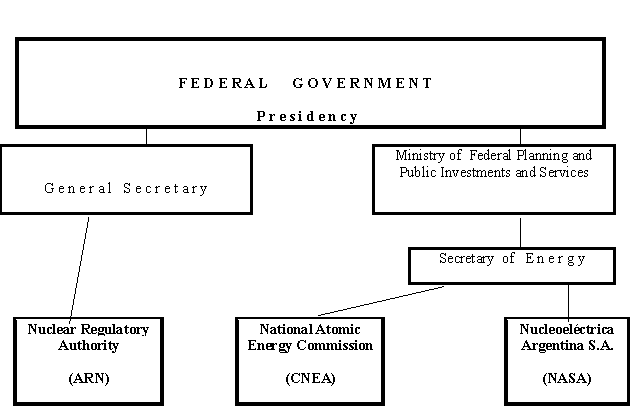
2.1.2 Current Organizational Chart(s)
Institutional Relationships
Financial Relationships : Fund movements
Technical and Supply Relationships with NASA
2.2. Nuclear Power Plants: Status and Operations 1
2.2.1. General
At present only around or less than 10 percent of electricity consumed in Argentina
is produced by nuclear plants. Since beginning of 1984 there are two nuclear
power plants (Atucha I and Embalse) in operation with a total net capacity of
935 MW(e), producing around 15 % of the total electricity generated in the period
1984-1990, a figure that later steadily decreased because of new expansions
of the total national capacity (see Table 7) and it was reduced to only 7.5
% in 2001 due to the additional impact of a long shut-down in Atucha-1. In parallel,
share of electricity produced by nuclear means was expected to increase during
the last decade with the construction and start-up of a third nuclear power
plant, Atucha II of 692 MW(e) net capacity, whose completion, however, has been
delayed up to now due to lack of funding.
TABLE 7. STATUS OF NUCLEAR POWER PLANTS
|
Station |
Type |
Net |
Operator |
Status |
Reactor |
|
|
|
Capacity |
|
|
Supplier |
|
ATUCHA-1 |
PHWR |
335 |
NASA |
Operational |
SIEMENS |
|
EMBALSE |
PHWR |
600 |
NASA |
Operational |
AECL |
|
ATUCHA-2 |
PHWR |
692 |
NASA |
Under Construction |
SIEMENS |
|
Station |
Construction |
Criticality |
Grid |
Commercial |
Shutdown |
|
|
Date |
Date |
Date |
Date |
Date |
|
ATUCHA-1 |
01-Jun-68 |
13-Jan-74 |
19-Mar-74 |
24-Jun-74 |
|
|
EMBALSE |
01-Apr-74 |
13-Mar-83 |
25-Apr-83 |
20-Jan-84 |
|
|
ATUCHA-2 |
01-Jun-81 |
|
|
|
|
Source: IAEA Power Reactor Information System as of 31 December 2002.
2.2.2 Reorganization of the Public Nuclear Sector
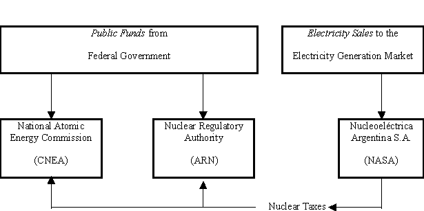
On August 30, 1994, a Federal Government Decree was issued to restructure the nuclear sector and CNEA. As a result, the National Nuclear Regulatory Authority (Autoridad Regulatoria Nuclear - or A.R.N.) was founded. The new Agency took over the regulatory responsibilities for nuclear activities that were previously carried out by CNEA. It establishes nuclear and radiological safety standards and formulates regulations related to physical protection and control of the use of nuclear materials. It is responsible for the licensing and regulations of nuclear installations and compliance with international safeguards. In addition, a shareholders company, Nucleoeléctrica Argentina S.A. (NASA) was established. NASA operates Atucha I and Embalse nuclear power stations and oversees the construction of Atucha II nuclear power station. The decree also directed NASA to pay annual royalties to CNEA and to ARN as licensing fees. Ownership has been handed to the Ministry of Economy, as a pre-privatization step.
In parallel, the Federal Government supported works at Atucha-2 NPP Project
initiated in 1981, were fully stopped and discontinued since the beginning of
1994 under a privatisation plan that was not accomplished and, in fact, is abandoned
at present. This 3rd NPP remains unfinished at 81% completion stage, with several
plant systems already operational, the main pending items being: completion
of electro-mechanical erection, I&C mounting, heavy water inventory and
first core fuel deliveries, and plant commissioning.
The above-mentioned 1994 Decree imposing the partition of former CNEA into 3 separate entities, CNEA, NASA and ARN, and paving the way for a future privatisation of NASA and its 3 NPPs, was later formally replaced by a "Federal Law for the Nuclear Activity" issued by Argentina´s National Congress in 1996 and put in force in 1998. This federal law ratified CNEA´s partition, and legally allowed privatisation of NASA and completion and start-up of Atucha-2 NPP by private companies through an international call for bids. Nevertheless, firstly due to lengthy elaboration of the legal instruments (federal law, administration decree, texts for the call for bids, etc.) and later due to the Federal Administration take over at the end of 1999, NASA privatisation as well as resumption of works at the long-time paralized Atucha-2 NPP did not happen up to now.
Very recently, the new federal administration ordered an update of Atucha-2
Project completion feasibility followed by first discussions with Siemens and
Framatome ANP, oriented to a final decision on project completion (see par.
4.1).
2.3 Supply of NPPs
As indicated before, Argentina´s NPPs have been designed by foreign suppliers : Siemens for the pressure-vessel-type PHWR Atucha-1 and Atucha-2, and AECL - Italimpianti for the CANDU-6 type Embalse NPP. These companies were also the main contractors in the respective projects, though a large participation of domestic companies was implemented in each case. These participations ranged between around 35 % in the first project (Atucha-1) to around 50 % in the last one (Atucha-2). In the case of Atucha-2 a joint Siemens-CNEA company, ENACE S.A., had been set-up to act as architect-engineer, a company/role that ceased in 1994 with the paralization of the project.
In the area of new concept development, CNEA and INVAP have carried out up to now a number of R&D and engineering activities within the so-called CAREM Project, a small modular passive PWR with a minimum capacity of 27 MWe, including recent studies for its scaling to around 300 MWe.
2.4 Operation of NPPs
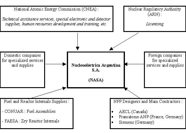
As indicated before, the owner and operator of Argentina´s NPPs is the state-owned company Nucleoeléctrica Argentina S.A. (NASA), since September 1994.
Main current suppliers including fuel supplier are indicated in sections 3.3 and 3.4. Designer companies, Siemens, AECL, and now Framatome ANP, rank among the main current suppliers for services, repairs and replacements. Some companies from Germany and Canada that participated in the NPP construction and manufacturing activities of each NPP Project are also currently providing assistance services. Other complementary services and supplies are provided by domestic companies.
Fuel assemblies are steadily provided by the domestic company CONUAR S.A., for attending the on-power refuelling of both operating NPPs. Zry-made reactor internals to be replaced are provided by FAESA. Special electronic equipment and special neutron and gamma detectors and chambers are provided by CNEA. Other complementary services in the areas of material behavior, NDT, water chemistry, safety analysis, etc. are also provided by CNEA.
Operator training is provided at basic levels at the NPPs themselves, while post-graduated training is provided by CNEA. Certain additional training is also provided at the plants themselves through limited scope simulators.
Finally, annual re-training is carried out with the utilization of the full scope simulators of :
· Eletronuclear S.A., at Angra dos Reis, Brazil, for Atucha-1 operators.
· Hydro-Quebec, at Gentilly, Canada, for Embalse operators.
2.5 Fuel Cycle and Waste Management
In the past a quite intense activity was carried out by CNEA in the areas of
uranium and thorium exploration and evaluation. While no significant deposits
of thorium were found, U deposits found gave rise to an important and large
mining activity also carried out by CNEA, especially in the provinces of Mendoza,
Salta and Chubut. Later, changes in the international U market conditions together
with the high domestic costs during the ´90s, led to a progressive abandon
of U mining activities in the argentinean territory.
During the last decade current Uranium supplies came and come from imports in
the international market. These imports include : natural, low enriched (around
3.4%) and medium enriched (around 20%) Uranium supplies. These correspond to
the main consumer installations: Embalse (Candu-type) plant employees Natural
Uranium fuel; Atucha-1 employes Slightly Enriched (0.85%) Uranium obtained from
the mixing between natural and 3.4% enriched U; research and production reactors
(both domestic and exported) normally employ 20% enriched U.
Since 2002 a new planning is aimed at reinitiating domestic Uranium production from the reserves in the country´s territory.
Production of UO2 powder is carried out by CNEA's daughter company DIOXITEK S.A. (100% CNEA owned) presently established at Cordoba city and foreseen to be moved to Mendoza province. Technology development for zirconium sponge production has been carried out at Bariloche, while manufacturing of zircaloy tubes for fuel element cladding and complementary pieces, coolant channels, instrumentation lances and other reactor internals is currently carried out by another CNEA's daughter company, FAESA (55 % CNEA owned), with a production plant installed at Ezeiza Atomic Centre.
Manufacturing of fuel assemblies is carried out by another daughter company of CNEA, CONUAR S.A.(35% CNEA owned), with its plant located close to FAESA's plant in Ezeiza Atomic Centre. CONUAR produces the fuel assemblies currently required by Atucha-1 (SEU fuel), Embalse (natural U fuel) and the research and production reactors either operating in Argentina or exported by CNEA or INVAP S.E. (see section 4.5).
According to the Federal Law for "Radioactive Waste management", CNEA is responsible for supervision of the overall treatment of such wastes coming from any nuclear user in the country, and in particular for assuring the final disposal of low, intermediate and high level radwastes.
High level radwastes of NPPs, namely irradiated fuel assemblies, are up to now stored in each NPP : in both plants they are initially stored at the respective fuel pools and this modality is followed up to the end in Atucha-1 which has a second fuel pool; Embalse has a dry storage facility where irradiated fuel is stored after spending 5-6 years in the fuel pool. Due to a province of Cordoba regulation forbiding transportation of any radioactive waste through this province, where Embalse NPP is located, this plant has to proceed with all such radwastes within the own plant.
For most of all cases CNEA assures radwaste treatment and storage at its Ezeiza Atomic Center. This includes intermediate and low level radwastes from any origin within the country, as well as spent fuel assemblies from Argentina´s research and production reactors.
CNEA, according to the same federal law, is responsible for the reception of each Argentine NPP at the end of its lifetime and for all the stages of its decommissioning and decontamination.
According to this law, two separate funds must be provided by each operating NPP in order to afford for radioactive waste treatment by CNEA and for decommissioning by CNEA.
2.6 Research and Development
The National Atomic Energy Commission (CNEA) remains as an institute for research
and development in the nuclear field, as well as for provision of technical
services and assistance to nuclear power plants, other nuclear installations
and nuclear and non nuclear application users, both in the domestic and international
markets. Most of production activities previously carried out by CNEA, are now
handled by private interests, with the main exceptions of radioisotope production
and specific instrumentation and electronic equipment.
As a result, CNEA ´s main areas of activity are:
¨ Basic and applied research in the main branches of physics, material sciences,
chemistry, radiobiology, etc.
¨ Technology development and applications in nuclear engineering (reactor
physics, reactor design, thermal-hydraulics, operation assistance tools, safety
and risk analysis, etc.); electronic and nuclear instrumentation developments;
reactor and neutron / gamma applications, including different medical applications
in particular BNCT; industry; agricultural food conservation and medical devices
sterilisation, etc.
¨ Nuclear Reactor Projects, mainly related to the already mentioned small
sized modular passive PWR NPP (Carem Project) : initial version of 27 MWe and
studies for scaled up versions in the range 100 to 300 MWe.
¨ Nuclear Fuel Projects : design, manufacturing and utilization of Slightly
Enriched Uranium fuel use in the HWR Atucha-1 NPP, CARA Project (for joint manufacturing
of Atucha and Embalse fuel assemblies), etc.
¨ Human resources education and training at the technician level for reactor
operators; as well as at university grade, post-grade and doctoral levels at
3 complementary institutes: Institute Balseiro at Bariloche, Institute for
Nuclear Studies at Ezeiza and Institute Sabato at Buenos Aires.
¨ Operation of nuclear facilities: nuclear reactors RA-1 and RA-3 in Buenos
Aires area, RA-0 in Cordoba city, RA-4 in Rosario city, RA-6 in Bariloche city
and RA-8 in Pilcaniyeu Technological Complex, cyclotron for radioisotope production,
high pressure test loop, etc.
¨ Technical services and assistance to the operating NPPs in Argentina,
Atucha-1 and Embalse, including engineering, works, equipment provisions, replacements,
back-fitting activities, etc., covering a wide range of disciplines from specific
neutron propagation studies, thermal-hydraulics, safety, mechanical, electronic
and electrical engineering, neutron detectors (self-powered and others), specific
safety-qualified electronic equipment, etc.
¨ Technical services and assistance to various national and foreign customers
covering conventional electric power plants, other industrial plants, metal-mechanical
component suppliers, hospitals and other medical centres, other private companies
devoted to nuclear applications, and Argentine exported nuclear reactors in
countries like Peru, Egypt, etc.
¨ Radioisotope production,
including large amounts of Cobalt-60 and Molibdenum-99, is generated in:
- Ezeiza Atomic Center´s RA-3 Reactor;
- Ezeiza Atomic Center´s Ciclotron;
- Embalse Nuclear Power Plant.
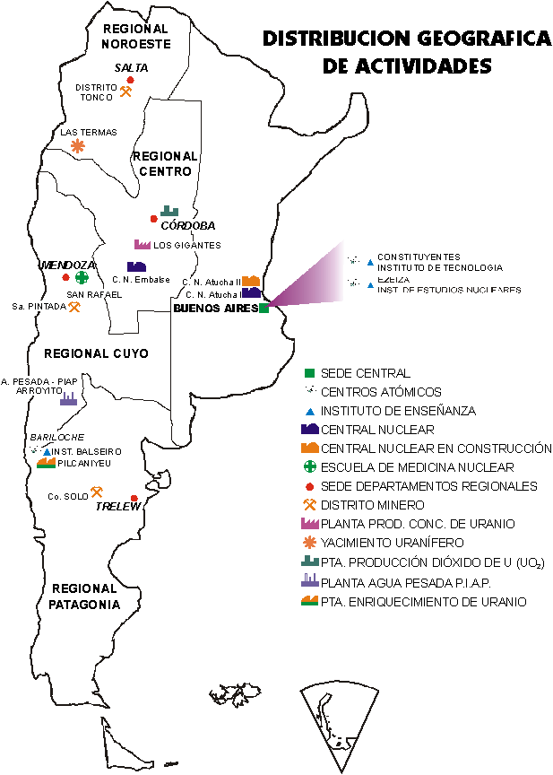
The main CNEA facilities are concentrated in:
¨ Constituyentes Atomic Center (CAC) in Buenos Aires area;
¨ Ezeiza Atomic Center (CAE) in Buenos Aires area;
¨ Bariloche Atomic Center (CAB) close to the southern town of Bariloche;
¨ Pilcaniyeu Technological Complex, near Bariloche.
These are complemented by several distributed CNEA delegations in different
places of the Argentine territory, providing support for domestic Uranium explorations,
mining and conversion activities.
2.7 International Co-operation and Initiatives
2.7.1 General
International co-operation in the field of nuclear power development and its implementation is quite extensive between the main entities acting in Argentina´s nuclear sector and foreign or international companies, governments and organizations. Such co-operation is first of all promoted and carried out by CNEA, ARN and NASA, and a very special link exists between them and the IAEA.
Specific links exist between CNEA and foreign partners in R&D activities in a wide area, from basic studies and development with first world entities (like US-DOE, France´s CEA, Japan´s JICA, etc.).
At the other extreme, NASA has a special collaboration agreement with Brazil´s Eletronuclear sharing brazilian/argentinean man-power during NPP outages in Brazil or Argentina, as well as other topics.
Special links also exist with latin american countries, partly promoted by IAEA through the Latin America Area Projects, ARCAL Projects. This includes not only the other countries having NPPs in the region, namely Brazil, Mexico and Cuba, but others having nuclear reactors like Chile and Peru, or having some type of nuclear activity.
Every year CNEA receives a significant number of foreign nuclear graduated people from other countries in the Americas, Africa and Asia, in particular through IAEA granted fellowships, for being trained in a large number of areas.
2.7.2 Exports
Exports from Argentina's nuclear sector mainly include:
¨ Nuclear
Reactors for Research and Radioisotope Production. This activity was initiated
by CNEA almost 25 years ago with the RP-0 and RP-10 reactors for IPEN, Peru.
Later it was taken over by another CNEA´s daughter company, INVAP S.E., with
similar or improved exports to Algeria, Egypt and Australia;
¨ Radioisotopes,
mainly Cobalt-60 produced at Embalse NPP´s adjuster rods and later processed
(mainly as sealed sources for industrial or medical use) at CNEA´s plant in Ezeiza Atomic Center;
¨ Specific
provisions for the exported installations (new or additional capabilities, instrumentation,
improved mechanical systems, etc.), as well as specifically designed and manufactured
electronic equipment, neutron and gamma detectors and chambers, etc. for different
foreign customers.
2.8 Human Resources Development
General development of Human Resources in the nuclear field is one of CNEA´s
responsibilities according to the federal law and, in practice, it has become
one of the most firmly carried out activities of this agency. This includes:
· Specific education and training at the technician level for reactor operators,
as well as in other areas according to current needs
· University grade, post-grade and doctoral level courses and thesis, mainly
through 3 complementary institutes: Institute Balseiro at Bariloche, Institute
for Nuclear Studies at Ezeiza and Institute Sabato at Buenos Aires.
In the second group of activities some good examples are the following:
Ø Master of Sciences and PhD in nuclear engineering and in physics,
at Institute Balseiro and Bariloche Atomic Center.
Ø Master of Sciences and PhD in material engineering, at Institute Sabato
and Constituyentes Atomic Center.
Ø Master of Sciences in Nuclear Reactors and in Radiochemistry at Institute
for Nuclear Studies, open also to foreign students with the support of IAEA.
Ø Post-grade in Applications of Nuclear Energy for Engineers through Institute
Balseiro
In all these cases the activities are carried out by CNEA in association with one or more national universities. Some of these activities also include short or medium term stays at the nuclear power plants.
Frequently, part of the corresponding graduates of these activities enter the
staff of nuclear power plants.
In turn, NASA regularly organizes, according to the needs, specific training
activities for the new personnel at the different levels of responsibility and
specialities, as well as complementary activities for normal plant staff.
This includes specific short courses, on-the-job training for the various operational
and maintenance functions, specific training at partial scope simulators and
regular annual training and re-training at the full scope simulators. These
are Hydro-Quebec´s Gentilly simulator (Gentilly-1) in Canada for Embalse
NPP staff, and Eletronuclear´s Mambucaba simulator (near Angra dos Reis)
in Brazil for Atucha-1 NPP staff. Other complementary activities are carried
out in order to fully comply in each case with the Nuclear Regulatory Authority
(ARN) standards and specific regulations established for each NPP personnel
position licensing. The general plan on training and re-training of NPP staff
is elaborated each year by NASA and submitted for approval to ARN.
Finally, the Regulatory Body ARN maintains a permanent monitoring, control and
approval/denial of all these NASA activities related to personnel training and,
in addition, organizes and executes the formal examinations to NASA staff candidates
for obtaining or renewing the "post licensing" and / or the "specific
authorization" corresponding to each operation or maintenance position
in the plant. Complementing these activities, ARN also carries out an annual
programme on graduate-level teaching in the areas of radiological protection
and nuclear and radiological safety, as indicated in par. 3.1.8. Some of these
activities are executed with the support of IAEA and are also open to foreign
students.
3. NATIONAL LAWS AND REGULATIONS 1
3.1. Safety Authority and the Licensing Process
The licensing process for nuclear power stations involves interaction between the Operating Organization and the Regulatory Authority starting at the earliest steps of a projected installation. The role of the Regulatory Authority is to establish "Requirements", "Recommendations" and "Requests for Information" and to issue construction and operation licenses. "Requirements" must be carried out by the Operating Organization.
"Recommendations" should be carried out unless it is shown by the Operating Organization that they are not necessary, or that the same objective can be achieved better by other means. The "Requests for Information" are issued by the Regulatory Authority in order to further evaluate or validate studies already presented by the Operating Organization. Standard AR 0.0.1 establishes general framework for the construction, operation and regulation of nuclear power stations.
Procedures to the Regulatory Authority for applying for a nuclear operating
license is described in standard AR 3.7.1. These include:
· Preliminary Safety Report (PSR) nine months prior to requesting the construction
license (does not include the work for site preparation).
· Systematic presentation of information, changes in design and other requirements
as needed two months after presenting the PSR and up to one month before the
reactor is loaded with the reacting combination of moderator and fuel.
· Monthly Progress reports on the construction of the nuclear power stations
after the granting of the construction license.
· Quality Assurance (QA) programme, QA manuals and QA information starting
with the presentation of the PSR. The QA programme must include organizations,
system of documentation, verification of the design, purchase, materials, processes,
inspections, tests, and corrective actions, as well as registry and its control.
· Organization chart for Operation, and the Staff Training Programme in
the beginning of the construction. It
should be modified when changes are proposed.
· Progress reports during non-nuclear commissioning 24 months prior the
predicted first criticality.
· Progress reports about the commissioning up to one week prior the first
criticality.
· Final Safety Report (FSR) 12 months prior the first criticality.
· Additional information and modifications to the FSR up to one month prior
the reactor is charged with moderator and fuel.
· Operating Manuals including the Radiological Code of Practice four months
prior the first criticality.
· Final report of the QA programme four months prior the first criticality.
· Request for individual operators licenses four months prior the first
criticality.
· Emergency Plan three months prior the first criticality.
· Constitution of an Ad-hoc Committee for Nuclear commissioning and operation
three months prior the first criticality.
· Maintenance Manuals one month before requesting the licence of operation.
· Report of the Ad-hoc Committee at the end of the Nuclear commissioning.
·
Final version of the Operating Manuals at the end of the commissioning.
Construction and operating license outlines the responsibilities of the director of the nuclear power station and the Operating Organization. License is given for an undefined period and may be cancelled, suspended or modified by the Regulatory Authority in case of non-compliance to the regulations. The license can include temporary requirements. Only licensed staff can operate Nuclear power stations.
The Operating Organization must have a Technical Review Committee (TRC) and
an Internal Safety Committee (ISC) which should meet at least once a month in
order to analyze nuclear operations; to asses the likelihood of failures and
abnormal events; and, to carry out the evaluation of any modifications to the
original design of the installation before these are presented to the Regulatory
Authority. The director of operations must be advised by the Internal Safety
Committee on any issues related to radiological and nuclear safety.
The "conditions and the limits of operation" are established in the
license and require the pre-approval of the Regulatory Authority for any modifications.
The license specifies the limits of radioactive effluents to the environment
and states the requirements for annual exercise of the Emergency Plan. The license
also defines procedures related to the "mandatory documentation",
the operators retraining programme, the communication channels with the Regulatory
Authority, and the relation with the "resident" inspectors.
3.1.1. Regulatory Authority
The Nuclear Regulatory Authority (in Spanish, ARN) was created as an autarchic
entity under Act 24,804 known as Nuclear Activity National Act, which came into
force on April 25th, 1997, to succeed the National Nuclear Regulatory Board.
The Nuclear Regulatory Authority reports directly to the Argentine Presidency
and is empowered to regulate and control the nuclear activity with regard to
radiological and nuclear safety, physical protection and nuclear non proliferation
aspects.
The objective of the Nuclear Regulatory Authority is to establish, develop and
enforce a regulatory system applicable to all nuclear activities within Argentina,
as well as, to advise the Executive on issues under its purview. The goals of
these regulatory system are:
· To provide members of the public with an appropriate level of protection
against harmful effects of ionizing radiation.
· To ensure a reasonable degree of radiological and nuclear safety for nuclear
activities performed in Argentina.
· To ensure that nuclear activities are not diverted for unauthorized purposes
and are performed in accordance with international agreements to which the Nation
is signatory.
· To establish criteria and standards in order to prevent deliberate actions
from being committed which may either have severe radiological consequences
or lead to the unauthorized removal of nuclear materials or other materials
or equipment of nuclear interest.
The effective direction and management of the Nuclear Regulatory Authority is carried out by the Boards of Directors. The Boards of Directors is composed of six members appointed by the Executive, two of which shall be nominated respectively by the Senate and the House of Representatives. The term of office of each Director shall be six years, with one third of them being chosen every second year. Technical and professional qualifications in the specific field are selection criteria for the Director's office.
The ARN organizational structure has been approved by a Board resolution in
accordance with the provisions of Act 24,804. The relevant organization chart
is shown in Chapter 1 of the Main Report (The Main Report is only available
in Spanish).
3.1.1.1. The Argentine Regulatory System
In its capacity as the national authority on radiological and nuclear safety,
non-proliferation assurances and physical protection issues, the ARN grants
authorizations, licenses or permissions, as appropriate, in connection with
practices associated with radiation sources. In addition, the ARN performs control
activities to ensure that persons responsible for each practice comply with
the provisions set forth in the standards and other regulatory documents. From
the beginning of the regulatory activities in the country it was recognized
that to efficiently play this role an appropriate scientific and technological
expertise was needed to assess, based upon an independent criterion, the design,
construction, operation and decommissioning of the facilities subject to control.
Within this framework, the global strategy contained in the Argentine regulatory
system has focused in the following basic principles:
· Adopting specifics standards on radiological and nuclear safety, safeguards
and physical protection.
· Conducting regulatory inspections and audits to verify compliance with
licenses and authorizations granted.
· Carrying out studies and assessments on radiological and nuclear safety,
safeguards and physical protection, for the purposes of the licensing process.
· Promoting scientific and technological development regarding radiological
and nuclear safety, safeguards and physical protection.
· Providing personnel training in connection with radiological and nuclear
safety, safeguards and physical protection, directed at both personnel responsible
for the safety of the facilities and performing regulatory activities.
3.1.1.2. Radiological and Nuclear Safety
According to the Argentine regulatory system the organization (owner or operator) dealing with the design, construction, commissioning, operation and decommissioning stages of a nuclear facility shall take full responsibility for the radiological and nuclear safety of the facility in question. No event affecting radiological and nuclear safety shall relieve said organization, referred to as Responsible Entity, from its responsibility in each stage of the project. The compliance with the regulatory standards and requirements is to be considered as a minimum requirement which does not relieve said organization from the obligation to take any action necessary to ensure the radiological and nuclear safety of the facility.
From the licensing process standpoint, facilities are divided into two groups:
major and minor facilities, according to the associated radiological risk involved.
For major facilities the ARN grants operating licenses while for minor facilities
it grants operating authorizations. An application for a license or authorization
will be accepted for examination provided that it is accompanied by an appropriate
preliminary nuclear safety assessment, the depth of which shall be in accordance
with the radiological risk associated with the facilities concerned.
Mayor facilities require three types of licenses: construction, operating and
decommissioning licenses. Licenses shall be granted to the Responsible Entity,
that is, the organization liable for the safety of such facilities. The construction
license for a given facility shall be granted upon compliance with standards
and requirements applicable to location, basic design and expected safety level
for future operation.
In order to be issued an operating license, the Responsible Entity shall prove
compliance with applicable specific conditions, standards and requirements.
As for the ARN, it performs an independent evaluation of the technical documents
and detailed studies field, the reports in connection with inspections conducted
during construction, the results of preliminary operation activities, etc.
It should be particularly noted that since the beginning of the construction
stage the ARN evaluates the ability of the Responsible Entity to take its responsibilities.
Argentina has adopted performance-based nuclear safety regulations. This requires
both the Responsible Entity, as regards its proposals, and the ARN, in connection
with its independent evaluation, to make a remarkable effort such that a final
satisfactory result is attained.
Accordingly, the interaction between the Responsible Entity and the ARN shall be carried out on a permanent basis throughout the licensing process.
The evaluations prior to issuance of a license for the operation of a major
facility include matters such as quality assurance, methods of construction,
provisions for inspections during operation, methods of operation, etc. In addition,
if a facility has a potential for accidents which may affect members of the
public, it is required that emergency plans be implemented in co-ordination
with the relevant federal, provincial and local organizations.
According to the ARN requirements, the whole staff of the Responsible Entity
shall be properly trained and qualified and demonstrate an aptitude in accordance
with their duties in a major facility. The Responsible Entity must also apply
to the ARN for individual licenses for personnel whose activities could substantially
affect safety. Applicants for an individual license are nominated by the Responsible
Entity and separately subjected to the independent evaluation of the ARN. Training
and qualification requirements for staff members generally cover four areas:
basic training, specialized training, in-job training and psycho-physical fitness.
Every function within the organization chart shall be fulfilled by staff members
whose background meets the relevant requirements. Such required qualifications
will include, if appropriate, basic university education in accordance with
the nature of the responsibility to be taken. Both the specialized and in-job
training shall be duly certified. Applicants shall be examined by ad-hoc examination
boards.
Two types of regulatory documents are issued for the purpose of certifying the
skills of the staff concerned. The first one consists in an individual license
certifying that the applicant possesses the basic and specialized training suitable
to take up a certain duty in a given type of facility. This document is issued
at the applicant's request and has no expire date. It is not, however, enough
to certify the ability of an applicant to take up a given duty in a facility.
Accordingly, to be accepted for performing a key safety-related responsibility
in a given facility, the applicant needs in addition to the individual license
a specific authorization, which has to be requested to the ARN by the Responsible
Entity. For this purpose, the applicant shall prove a specific knowledge of
the facility in question, as well as a suitable in-job training and an adequate
psycho-physical fitness. This specific authorization is valid for a period that
shall not exceed two years.
As indicated above, for the operation of minor facilities the organization liable
for any practice involving radioactive material or ionizing radiation is required
to apply for an operating authorization. For the operation of minor facilities
the ARN has the authority to require that the organization liable for any practice
involving material or ionizing radiation applies for an operating authorization.
This document shall be issued by the ARN in favour of that organization upon
assessment of the documents filed and the results of the preliminary operation-related
inspections, provided that all applicable standards and prerequisites are met
and qualified staff is brought in. Additionally, for the operation of a minor
facility, individuals involved are required to hold a specific individual permission
applicable to a given practice. In order to be granted such a permission, the
applicant shall meet several requirements, namely to possess a suitable basic
training, an appropriate specialized training and enough in-job training in
accordance with the provisions of the relevant specific standards.
All individuals and legal entities desiring to apply to the ARN for licenses,
operating authorizations, specific authorizations and individual permissions
or radioactive material transport certificates shall pay a licensing or inspection
fee. Furthermore, the ARN is empowered to impose sanctions and/or fines in the
event of non-compliance with the radiological safety standards regarding medical
and industrial applications, as well as with ionizing radiation research and
teaching regulations.
3.1.1.3. Safeguards and Physical Protection
Safeguards and nuclear non-proliferation assurances are an essential aspect
in the Argentine regulatory system. They are a group of requirements and procedures
applicable to both the nuclear materials and other materials, equipment and
information of nuclear interest, aimed at ensuring, with a reasonable degree
of certainty, that such elements are not intended for an unauthorized use, and
that the international agreements signed in this matter are appropriately respected.
The safeguards may be national or international in nature, with the international
safeguards being divided into regional and global. National safeguards are defined
by the provisions set forth in the regulatory framework adopted by each State.
In the case of Argentina, the ARN has established the guidelines of the Argentine
Accountancy and Control System for nuclear materials and other materials, equipment
and facilities of nuclear interest. As far as the international safeguards and
non-proliferation assurances are concerned, their application proceeds in accordance
with the provisions of the agreements on non-proliferation of nuclear weapons
ratified by Argentina. In this case, the safeguards may be applied by regional
or global international organizations and are aimed at detecting within reasonable
time and a reasonable degree of certainty the diversion of "significant
amounts" of nuclear materials for purposes banned by the agreements by
virtue of which those safeguards are applied.
In this regard, it is worth mentioning the "Bilateral Agreement between
the Argentine Republic and the Federative Republic of Brazil for the exclusively
peaceful use of nuclear energy" signed in the city of Guadalajara in 1991.
By virtue of this agreement an agency was created, designated as "Brazilian-Argentine
Agency for Nuclear Material Accountancy and Control" (ABACC) the essential
objective of which is the implementation of the "Common System for Accountancy
and Control of Nuclear Materials" aimed at ensuring that said materials
are not diverted for the manufacturing of nuclear weapons or other nuclear explosive
devices.
Immediately after the bilateral agreement came into force, a multilateral agreement
was concluded by Argentina, Brazil, the ABACC and the International Atomic Energy
Agency (IAEA) for the application of safeguards (referred to as Quadripartite
Agreement). This agreement commits the IAEA to applying safeguards in both countries
for nuclear materials in connection with all nuclear activities in Argentina
and Brazil, based upon the "Common System for Accountancy and Control of
Nuclear Materials".
The Argentine regulatory system also contemplates, with special attention focused
on the national regulatory function, the physical protection against robbery,
removal or unauthorized use of nuclear materials, and sabotage against nuclear
facilities. In this respect, the ARN takes full responsibility for requiring
the Responsible Entity to implement a complete physical protection system applicable
to nuclear facilities and materials in accordance with the regulatory requirements
set forth by the ARN. In particular, the "Convention on Physical Protection
of Nuclear Material", regarding international transport of these materials,
was opened to signature on March 3, 1980, in the IAEA's Vienna headquarters
and the United Nation's New York headquarters; Argentina adopted this Convention
under Act 23,620 and then ratified it.
3.1.1.4. Transport of Radioactive Material
The transport of nuclear material within Argentina shall be carried out in accordance
with the provisions of the IAEA's "Regulations for the Safe Transport of
Radioactive Material" which 1985 edition (amended in 1990) came into force
on 11 December 1993.
All international, regional and national organizations responsible for regulation
of land, air, river and sea transport of hazardous materials have endorsed the
safety criteria contained in regulation AR 10.16.1 related to "Radioactive
Material Transport", literally in accordance with the aforesaid IAEA Regulations.
This regulation provides persons, goods and environment with a suitable safety
level during normal transport of radioactive material, as well as in the event
of any accident. In order to protect workers and members of the public under
normal transport conditions, this regulation sets forth prerequisites which
essentially limit the dose rate in the environment of the packages to be transported
and the non-fixed contamination in their external surface.
3.1.2. Institutional Relations
Within the context of its regulatory function, the ARN maintains a close and
varied interaction with domestic and foreign, governmental and non-governmental
organizations, as well as with international agencies. Such an interaction has
the following objectives:
· To facilitate the exchange of experiences and information and the participation
in developing international recommendations to address issues related to radiological
and nuclear safety, nuclear non-proliferation assurances and physical protection;
·
To establish and develop technical co-operation agreements;
·
To promote co-operation in order to improve effectiveness and efficiency
of the international safeguards system through the participation of experts
and the development of specific techniques in the country.
Furthermore, the ARN is actively involved in negotiating international instruments
in connection with the nuclear regulatory function and also in their subsequent
implementation. In addition, the ARN contributes to the definition of Argentine
regulatory policies upheld in different international forums.
The negotiation of national and international agreements has always been one
of the most important tasks within the framework of the institutional relations.
The ARN maintains currently valid agreements with national and foreign universities,
public hospitals, the Federal Police and the Coast Guard, as well as with American,
Canadian, Spanish and Swiss regulatory authorities, among other countries. During
1998, international agreements were concluded with Germany's "Gesellschaft
für Anlagen und Reaktorsicherkeit (GRS) mbH" and France's "Institut
de Protection et de Sûreté Nucléaire" (IPSN). In the
national sphere, agreements have been signed with the Argentine Border Guard,
the University of Buenos Aires' Faculty of Engineering and "Otto Krause"
Technical Education School Nº 1.
The ARN attaches great importance to the link with the International Atomic
Energy Agency (IAEA). This link can be defined as having three key principles:
· Attending the regular meetings of the so-called IAEAs "policy-making"
organism;
· Participating in meetings of high-level expert committees advising the
IAEA Director-General on issues in connection with nuclear safety and safeguards,
as well as in activities related to negotiation or implementation of international
agreements significant for nuclear safety; and
·
Contributing experts for taking part in technical assistance missions
in various countries, preparing safety-related publications and training foreign
trainees.
The ARN participates in the National Commission for the Control of Sensitive
and War Material Exports to provide advice in cases related to nuclear exports.
During 1 998, it prepared and issued judgements on the export applications filed,
then granting the relevant export authorizations.
The Comprehensive Nuclear Test Ban Treaty (CTBT) adopted by the United Nations
General Assemb1y in September 1996, is a matter of permanent work for different
sectors in the ARN. In fact, with the purpose of verifying compliance with the
essential obligation set forth in the Treaty, an International Surveillance
System was established envisaging the intensive use of detection techniques.
In the case of radionuclide and infrasound technique, the ARN is the responsible
organization.
3.1.3. Regulatory Inspections
In Argentina, there are two nuclear power plants in operation, one under construction,
six research and radioisotope production reactors, 24 major radioactive facilities
and more than 1 500 facilities (for medical, industrial, research and teaching
purposes) which utilize radioactive materials or sources and radiation-generating
systems. Those facilities are devoted to various purposes such as electric power
generation, basic and applied research, or the use of ionizing radiation in
the field of medicine and industry. Such various facilities are located all
around the country and their complexity varies in a very wide range.
The ARN's regulatory functions aimed at controlling those facilities include
analyzing design and operation-related documents, permanently assessing safety
during operation, and verifying by means of regulatory inspections and audits
the compliance with the provisions of the license concerned. The analysis and
assessment functions are discharged by staff members skilled in the field of
radiological and nuclear safety who use modern information technology for data
management and are acquainted with the use of calculation codes, in order to
validate documents supplied by the licensee based upon their own independent
criteria.
The ARN's regulatory control action aimed at controlling the facilities also
includes a programme of routine and non-scheduled inspections for the follow-up
of activities related to safety and verification of compliance with the provisions
of the relevant license. Facilities subject to regulatory control are listed
in Table 8.
Routine inspections are aimed at a) supervising the facility's regular activities,
b) process monitoring and c) verification of compliance with the provisions
of mandatory documents. As far as nuclear power plants are concerned, inspections
are basically conducted by ARN's resident inspectors relying on the technical
support provided by the ARN analysis and assessment groups or by groups working
for the ARN under agreements or contracts.
Non-scheduled inspections are carried out either in the event of specific circumstances
or when the need arises to increase the inspection effort. In these cases inspections
are conducted by experts in a variety of disciplines, either from the ARN or
other ARN-related institutions.
TABLE 8. FACILITIES SUBJECT TO REGULATORY CONTROL
|
Facilities |
Number |
|
Nuclear power plants (one under
construction) |
3 |
|
Research reactors and critical
assemblies |
6 |
|
Particle accelerators |
4 |
|
Radioisotope or radioactive sources
production plants |
5 |
|
High-dose irradiation plants |
2 |
|
Fuel cycle facilities |
13 |
|
CNEA's waste management area |
1 |
|
CNEA's minor facilities |
26 |
|
Teletherapy centres |
108 |
|
Brachytherapy centres |
81 |
|
Nuclear medicine and radioimmunoassay
centres |
605 |
|
Gammagraphy |
48 |
|
Nuclear gauges |
266 |
|
Research and teaching centres
and other applications |
433 |
Source: Autoridad Regulatoria Nuclear.
3.1.4. Occupational Surveillance
Basic criteria supporting radiological safety establish that: all practices
involving the use of ionizing radiation shall be adequately justified, radiological
protection shall be optimized, dose limits and constraints shall be complied
with, and the likelihood of accidents (potential exposure) shall be kept at
a minimum level.
The ARN performs assessment of information related to occupational exposure
in the most important major and minor facilities. This work allows the ARN to
define behaviour indicators for radiological protection systems, to identify
tendencies, to verify compliance with dose limits, and to compare different
practices to each other.
3.1.5. Environmental Surveillance
The ARN performs environmental monitoring in the surroundings of the different
nuclear facilities in a manner fully independent from monitoring carried out
by the facilities themselves. In 1998, such a monitoring was carried out in
Atucha I and Embalse nuclear power plants, Ezeiza Atomic Centre, San Rafael
uranium ore mining plant, Cordoba uranium ore milling plant and the following
decommissioned plants for mining and milling uranium ores: Malargüe, Pichiñán,
Los Gigantes, La Estela, Los Colorados and Tonco.
3.1.6. Scientific and Technological Activities
The ARN carries out various kinds of scientific and technological functions
to support its regulatory activity. For this purpose, the ARN relies on appropriate
laboratories equipment and skilled personnel whose tasks consist in implementing
and validating the corresponding methodologies within different working sectors.
The ARN possesses various laboratories within the Ezeiza Atomic Center, located
in Ezeiza, province of Buenos Aires. These laboratories cover an area of 2000
m2 and are devoted to physical dosimetry, radiopathology and biological dosimetry,
radiochemical analyses, uranium particle detection, iodine 129 detection, radon
measurement, environmental sample processing, and internal contamination assessment.
Those facilities also include measurement laboratories (whole body counter,
gamma and alpha spectrometry laboratory, gross alpha and beta activity measurement
laboratory, and low background activity counter), and electronical support laboratories.
In 1998, supporting activities related to regulatory and development control
functions were performed within the following specific areas:
· Physical dosimetry;
· Internal contamination;
· Biological dosimetry;
· Programme of medical assistance on radiological protection;
· Diagnostic and prognostic indicators applicable to accidental overexposure;
· Prenatal irradiation effects on developing central nervous system;
· Nuclear tests detection;
· Use of thermohydraulic codes for assessment of nuclear power plant safety;
· Electronic developments applied to regulatory activities;
· Computer model development for assessment of nuclear power plant safety;
· Study on core material behaviour in nuclear power plants during severe
accidents;
· Development of techniques aimed at detecting undeclared nuclear activities.
Within the framework of the Comprehensive Nuclear Test Ban Treaty, a gamma spectrometry laboratory was in operation and served as a primary laboratory within the international network set forth in this Treaty.
3.1.7. Radiological Emergencies
The ARN evaluates the radiological and nuclear emergency procedures in case of accidents developed by facilities under control. Which actions are to be taken, who will take them and how they will be taken are the highlights of the emergency plan on which intervention is based. This plan contains all procedures to be followed in the event of an accident condition. For major facilities, the licensee shall take full responsibility for implementing an emergency plan; for minor practices, emergency procedures are required to contain accidents and minimize their consequences.
In accordance with its duties, the ARN will take steps in a subsequent stage
to minimize injury and damage, which may result from any incident, accident
or radiological emergency, through its own Radiological Emergency Intervention
System (SIER). The SIER is intended to
· To play a part as an intervening organization in the event of emergencies
which may arise in minor facilities and practices where accidents can not be
provided with adequate containment or affect members of the public, as well
as in the event of radiological emergencies in public areas.
The SIER consists of two groups: the Primary Intervention Group and the Support
Group. The Primary Intervention Group is on duty in weekly shifts all year round.
The Support Group is made up of the rest of the ARN technical staff members
who do not work in shifts but may be summoned when necessary. The SIER has the
specific equipment and necessary logistic infrastructure to ensure a prompt
and efficient intervention in the event of a nuclear accident or a radiological
emergency. It works in close relationship and has reached co-operation agreements
with other organizations such as federal and provincial Civil Defence Services,
the Federal Police, the Coast Guard, the Armed Forces and the Internal Security
Department.
3.1.8. Training and Technical Information
The ARN undertakes as a permanent activity the training of specialists in radiological
and nuclear safety, safeguards and physical protection, by means of training
courses and the participation in national and international congresses and expert
meetings.
The training activity is carried out through the Training Department in charge
of defining, organizing and co-ordinating courses, workshops and updating seminars.
The Postgraduate Course on Radiological Safety and Nuclear Safety organized
in accordance with the provisions of an agreement with the University of Buenos
Aires and the Ministry of Health and Social Welfare under the auspices of the
IAEA, has been uninterruptedly given on a yearly basis since its inauguration
in 1 980. Since then, a total number of 539 professionals have taken a degree,
roughly a half of them being foreigners.
3.1.9. Human and Economic Resources
The organizational structure of the ARN is made up of 215 established posts
and 6 posts pertaining to the Board of Directors.
Out of the total regular stall, 67% are university-degree holders. Out of the
total regular stall, 85% is devoted to specialized scientific and technical
functions within the ARN's sphere of activities, while the remaining 15% is
devoted to support and clerical jobs.
The total budget allocation approved for the year 1998 for the ARN was $ 18,622,065,
funded by the Treasury Department contributions, Specific Resources and Specific-Allocation
Resources.
Personnel expenditures accounted for 64.6% of the total current expenditure,
including contributions from the employer, and social security allowances. Consumption
expenditure and non-personnel services accounted for 16.9% of the total current
expenditure.
3.2. Main National Laws and Regulations in Nuclear Power
In the past, several Federal Government Executive decrees have identified CNEA as the Regulatory Authority on radiological and nuclear safety, including the protection of the workers, public and the environment against the effects of ionizing radiation, and the safety of the installations.
During the first years of nuclear activities in Argentina, there was no clear separation of the Regulatory Authority from the main operational safety group, since almost all NPPs operated in CNEA installations. In 1958, the regulations covered the whole country. At the same time research supporting regulatory framework was initiated to establish criteria to limit discharges of radioactive material to the environment and food pathways.
The regulatory setting in that time included the licensing activities, the
evaluation of design and the operation of nuclear power stations, the analysis
of accidents and regulatory inspections.
At present, the regulatory system covers all CNEA and NASA nuclear activities
and those of any third party in the country, as well as all uses of radionuclides
and radiation, except the use of X-rays, which are controlled by the Ministry
of Health. The standards for nuclear power stations established by the Regulatory
Authority are the following:
AR.3.1.1. Occupational exposure (design).
AR.3.1.2. Limits to radioactive effluents (design).
AR.3.1.3. Radiological criteria related to accidents and risk assessment analyses.
AR.3.2.1. General safety criteria applied to design.
AR.3.3.1. Reactor core.
AR.3.3.2. Heat removal System.
AR.3.3.3. Primary pressure system.
AR.3.3.4. Behaviour of fuel in the reactor.
AR.3.4.1. Protection of the core and safety instrumentation.
AR.3.4.2. Shutdown systems.
AR.3.4.3. Containment system.
AR.3.5.1. Essential electric supply.
AR.3.6.1. Quality assurance.
AR.3.7.1. Documentation for the Regulatory Authority prior to the commercial
operation.
AR.3.8.1. "Non-nuclear" commissioning
AR.3.8.2. "Nuclear" Commissioning.
AR.3.9.2. Communication of relevant events.
AR.3.10.1. Protection from earthquakes.
In Argentina, the "Operating Organization" is CNEA, NASA or other,
which is responsible for the radiological and nuclear safety in design, construction,
commissioning, operation and decommissioning of nuclear power plants. It is
responsible for making reasonable efforts toward the safety of the nuclear power
stations with enforcing the minimum compliance of the standards, stipulations
outlined in the Licence, and all the requirements established by the Authority.
The Operating Organization designates a "Person with Primary Responsibility"
to each nuclear power station in operation who is directly responsible for the
radiological and nuclear safety of the installation. The directors of Atucha
I and Embalse nuclear power stations have the primary responsibility for these
installations. The Operating Organization must give all the necessary support
to the "Person with Primary Responsibility" and must carry out an
adequate supervision in order to insure the correct and safe operation of the
plant. The "Person with Primary Responsibility" must make a reasonable
effort toward the safety of the plant in order to meet the minimum conditions
and the specifications of the License.
4. CURRENT ISSUES AND DEVELOPMENTS ON NUCLEAR POWER
4.1 Energy Policy
The bulk of the nuclear activity in Argentina has been legally formulated
and the responsibilities and means specified through the Federal Law Nº
24 804, or "Nuclear Activity Law", complemented by the Federal Law
Nº 25 018, or "Radioactive Waste Management Law".
Electricity generation through nuclear power in Argentina has been proceeding,
globally, steadily with no significant perturbations, though without any expansion.
Essentially, the two operating NPPs, i.e. Atucha-1 (357 MWe gross) and Embalse
(648 MWe gross), are required at every moment for base load operation ranking
in the uppermost positions among all kinds of generating stations. However,
the most relevant aspect is the non completion of Atucha-2 NPP, a highly completed
but long-delayed plant, exclusively due to the lack of financial means of the
state-owned utility, NASA.
The two operating NPPs perform very well under the highly competitive rules
of Argentina´s fully deregulated and open electricity generation market.
The resulting prices are comparatively quite low. At the same time, both plants
have a good record for safety aspects with no relevant incident or anomaly,
as well as doses to the personnel or the public along their plant life up to
now. All this leads to a reasonable public acceptance for nuclear power generation
in Argentina.
During the last decade, Nuclear power generation has represented annually between
7.5 and 9.% of the total electricity generation (of the order of 75-80 TWh).
This implies a good contribution to the national reduction of CO2 emissions.
Privatization of all NPPs including the completion of Atucha-2, all that in
a single package, was attempted in 1999 with no positive results. After that,
the idea has been abandoned by the federal administrations ruling the country
in recent years during the deep economic crisis the country suffered (1998-2003),
including the strong devaluation of the national currency (argentine peso) since
January 2002.
During the second semester of 2003 the new federal administration ordered a general update of Atucha-2 Project completion feasibility and, particularly, a reassessment of the remaining investment for project completion taking into account the reduction of the argentine peso value to around 1/3 of its former value (equivalent to 1 US$) and the fact that around 3 / 4 of such investment formerly corresponded to domestic expenses (mainly electro-mechanical erection works, and first core fuel and D2O supplies). The study is presently followed by the initiation of discussions with the plant designer, Siemens and at present also Framatome ANP, directed to a reappraisal of actions, works and financing possibilities for project completion.
In the area of radioactive waste management, federal law Nº 25018, assigns
to the National Atomic Energy Commission (CNEA) full responsibility for final
treatment and disposal, creating a special fund with this purpose to be contributed
essentially by operating NPPs.
Two particular points must be outlined with regard to waste management :
Ø
According to the Argentine Constitution, any import of radioactive waste is
forbidden.
Ø In several districts there
exist provincial and/or municipal regulations not allowing for any road or rail
transportation of radioactive wastes within such jurisdictions.
All these regulations impose hard challenges to the waste management activities.
In general, most of the nuclear power generation activity is carried out by
the state, i.e. the federal government, through :
Ø
the National Atomic Energy Commission (CNEA) in what concerns R & D, human
resources development and training, technical assistance, etc.;
Ø
the Nucleoeléctrica Argentina S.A. (NASA) company, the owner and operator of
NPPs.
Joint state-owned / private companies were set-up for the main supplies in the front fuel cycle : CONUAR, FAESA, DIOXITEK.
Applied research, basic engineering development and services to national and
foreign customers are provided by the state-owned company INVAP S.E. This especially
applies to the design and construction of research and radioisotope production
reactors for foreign customers.
All the nuclear activity is under the regulatory system implemented and executed
by the National Nuclear Regulatory Authority (ARN).
Concerning future plans related to Nuclear Power, it must be indicated :
Ø In the short term : increasing efforts for assuring
adequate NPP life management and the necessary refurbishments
Ø
In the medium term : completion or closure of
Atucha-2 NPP, at present finished at 81% level.
ØIn
the long term : planning is at present very
difficult, because of the current economical and financial crisis in Argentina.
However, it is regularly reaffirmed that the nuclear option remains open for
the long term, on the basis of : diversification of energy sources, almost exhaustion
of new potential hydro-power, safety of supply and emission-free energy´s international
policies and agreements.
At this moment Argentina is not sharing any foreign or international project of new concept and design development of NPPs, though is participating actively in several international technical committees and initiatives, mainly the "Generation IV" initiative of the US-DOE, as well as the "INPRO Project" of IAEA, both related to investigations of long-term innovative reactor concepts. In the short / medium term CNEA´s activity in the area are centered in its CAREM Project, a small size (25 to 300 Mwe) innovative and safety-passive PWR.
4.2 Privatisation and deregulation
The main features of the present Deregulated Electricity Market were outlined
before. However, a few special aspects will be reviewed.
1. Overall Legal Scheme
In 1992 the Federal Law Nº 24 065 has established :
· A
complete horizontal splitting of the whole Electricity Market, into 3 separate
sectors, with different companies in each one : a) Generation, b) Transport,
c) Distribution.
· Privatization
of almost all of state-owned assets
· Free
entrance for private investors in each electricity sector
· The
Secretary of Energy and the Electricity Regulatory Body (ENRE) are the Federal
Government entities for administration
of the whole new system
2. Electricity Generation Market
·
Fully
deregulated. Privatized companies are now a number of competing societies. New
investors have also entered the generation market for additional capacities,
especially with combined-cycle gas turbines (CCGTs).
· All
types of electricity generation (thermal, hydro, nuclear, etc.) are treated
and competing under identical conditions (Few exceptions for renewable energies,
especially in Patagonia).
·
Plant
output admission to the National Grid
dispatched by CAMMESA, by order of plant precedence according to lower Marginal
Generation Cost (fuel + miscell.) for fuelled (thermal and nuclear) plants,
or the declared water value for hydro-plants.
·
Generation
price is fixed by the total cost of
the most expensive (last) supplying plant at each hour.
As a result of these rules, base load requirements are essentially covered by
· Hydro-power
stations located on the large rivers Parana and Uruguay, and partially by some
other similar stations located mainly in the Comahue area (Neuquen and Rio Negro
Provinces), i.e. the largest rivers in the plains and partially in the foothills
of the Andes, having the lowest declared water values due to the very high availability
and stability of the necessary water flows.
· The
2 Nuclear Power Plants, Embalse and Atucha-1, with quite low fuel costs, i.e.
marginal costs.
· A
number of CCGT and GT plants having
a good location with regard to gas supply : at the exit of gas wells or close
to main gas pipelines.
The very large hydro-power capacity in the country, together with the very large and cheap domestic gas resources have led to a sustained decrease in generation prices to the utilities and some stabilization at around 25 - 28 US$ / MWh on the average, during the last years up to end 2001. After the dramatic argentine peso devaluation during 2002, its value decreased from 1 US$ to 0.33 US$ at the end of 2003. So, current prices remain at around 30-40 A$ / MWh, namely 10-14 US$ / MWh.
Due to their basically low fuel costs, both NPPs perform very well in this deregulated generation market: both plants are called for providing their 100 % capacity supply at every moment (base load). The fact that their initially foreseen privatization has not occurred up to now, does not modify at all this well ranked position. The owner and operator, Nucleo-eléctrica Argentina S.A. (NASA) is a fully state-owned company, financially independent and dependent only on its own incomes.
This leads NASA to a permanent effort in order to keep the plants on line at their maximum power capacity and to permanently monitoring any expense in fixed and variable costs of any kind : staff, maintenances, services, insurances, repairs, back-fittings, etc. and particularly fuel costs.
In connection with the last point, it must be mentioned the special project, already turning at 100 %, for replacing the use of Natural U by Slightly Enriched U (SEU) at 0.85 %, as fuel in the UO2 pellets of Atucha-1 reactor fuel assemblies (FAs). In this way, the very high manufacturing costs of these FAs (more than 6 m long) are well compensated by the near 100.% increase in their exit burn-up using the SEU fuel. Thus, the final fuel cost per KWh was reduced around 40 % in Atucha-1, allowing this NPP to compete very well with the cheapest CCGT plants.
Excluding the base load hydro-power plants, Embalse NPP remains the "number 1" lowest marginal cost plant of all the generation park, while Atucha-1 is within the 10 cheapest plants due to the above mentioned use of SEU.
Some very long unplanned shutdowns and heavy repairs in Atucha-1 during the last years have imposed a very high challenge to NASA, though staff efforts have, at any time, found solutions to these problems, together with the very good performance of Embalse NPP allowing a reasonable cash-flow for NASA, in spite of the very low average generation prices.
4.3. Role of the government in the nuclear R& D
As indicated before, the Federal Government plays a major or exclusive role
in this field, through the activities of the National Atomic Energy Commission
(CNEA) covering a large spread from neutron data, material research, and development
of new concepts in nuclear fuels and nuclear reactors, either research, radioisotope
production reactors or the small size Carem concept of NPP.
In the just-mentioned area of reactor development, this activity is specially
promoted by the state-owned company INVAP S.E., an activity that frequently
leads to very successfull results, like the exports of research and radioisotope
production reactors to various countries.
4.4. Nuclear Energy and Climate Change
As indicated in Section 1, up to now Argentina benefits of a relative small population within a very large territory, with an average population density of around 13.8 inhab./km2.
Combustion of fossil fuels still remains very low. Use of these fuels in the
transport activity plus in electricity generation do not pose at present a significant
problem. Contamination coming from these emissions is only of some concern in
Buenos Aires city and to a lesser extent in the following 2 larger towns, namely
Cordoba and Rosario.
In relation to electricity production, and for the long-term, there is a quite
general consensus that the nuclear option must remain open on several basis
but especially considering international policies and agreements in progress
related to the intensive use of emission-free energies like nuclear.
4.5 Safety and waste management issues
Both topics have been addressed previously. However, it must be recalled that
according to the Federal Law Nº 24.804, of Nuclear Activity :
Ø The National
Nuclear Regulatory Authority (ARN) is the national body responsible for organizing
and controlling the whole nuclear and radiological safety system involving installations,
personnel and the public. Most of its regulations are alligned with the international
regulations issued by the main agencies in the field, namely IAEA and ICRP.
Ø The National Atomic Energy
Commission (CNEA) is responsible of the final treatment and disposal of radioactive
wastes. This activity is proceeding accordingly for low and medium level wastes
at CNEA´s facilities in Ezeiza Atomic Center. Irradiated fuel is up to now stored
at each NPP after in-reactor service, in pool storage for both plants or in
dry storage for Embalse fuel after around 5-6 years decay.
REFERENCES
[1] Country Profiles 1995-96.
[2] Nuclear Regulatory Authority, Annual Report Synthesis, 1998.
[3] Data & Statistics/The World Bank.
[4] IAEA Energy and Economic Data Base (EEDB).
[5] IAEA Power Reactor Information System (PRIS).
Appendix 1.
International, Multilateral and Bilateral Agreements
|
AGREEMENTS WITH THE IAEA |
||
|
Signed: |
13 December
1991 |
|
Argentine
Senate |
Approved: |
5 August
1992 |
|
Brazilian
Parliament |
Approved: |
19 February
1994 |
|
The Quadripartite
Safeguards |
Entry into force: |
4 March
1994 |
|
Agreement;
INFCIRC/435. |
|
|
|
Not Signed |
|
|
Prefers
to apply the present procedures but is prepared to accept all inspectors
approved by the Board with exceptions. Letter: |
19 June
1990 |
|
|
|
|
INFCIRC
No: 143 |
Entry into force: |
13 March
1970 |
|
62 |
|
2 December
1964 |
|
|
|
|
Argentina/USA |
|
|
|
INFCIRC
No: 130 |
Entry into force: |
25 July
1969 |
|
|
|
|
INFCIRC
No: 168 |
Entry into force: |
3 October
1972 |
|
202 |
23 October
1973 |
|
|
224 |
6 December
1974 |
|
|
250 |
22 July
1977 |
|
|
25 |
22 July
1977 |
|
|
294 |
15 July
1981 |
|
|
296 |
14 October
1981 |
|
|
297 |
14 October
1981 |
|
|
303 |
8 July
1982 |
|
|
Entry
into force: |
27 February 1991 |
new ARCAL
agreement |
Entry into force: Signature: |
September 1984 4 December
1998 |
|
Entry into force: |
15 October 1963 |
|
OTHER RELEVANT INTERNATIONAL TREATIES etc. |
||
|
Entry into force: |
10 February 1995 |
|
Entry into force: |
18 January 1994 |
|
Entry into force: |
6 May 1989 |
|
Entry into force: |
17 February 1990 |
|
Entry into force: |
17 February 1990 |
|
Entry into force of: |
12 November 1977 |
|
Signature: |
21 September
1988 |
|
Ratification: |
14 November 2000 |
|
14 November 2000 |
14 November 2000 |
|
Entry into force: |
16 July 1997 |
|
Entry
into force: |
18 June
2001 |
|
Member |
|
|
Adopted |
|
|
Summary:
National authorities can use codes assuggested, to complement their rules
and regulations. |
|
|
|
Letter of: |
18 November
1988 |
|
Member |
|
Appendix 2.
DIRECTORY OF THE MAIN ORGANIZATIONS, INSTITUTIONS AND COMPANIES INVOLVED IN
NUCLEAR POWER RELATED ACTIVITIES
NATIONAL
ATOMIC ENERGY AUTHORITY
|
|
|
|
|
|
Comisión Nacional de Energía
Atómica (CNEA) |
Tel: +54-11- 6323. 1201 |
|
(National Atomic Energy Commission) |
Fax: +54-11- 6323. 1170 |
|
Mail address : |
|
|
Avenida del Libertador 8250 |
Telex: 23458 CNEA or 25392 PREAT AR |
|
1429 - Buenos Aires, Argentina |
Cable: PRESIATOM BAIRES |
|
|
|
|
Autoridad Regulatoria Nuclear
(ARN) |
Tel: +54-11- 6323. 1248 |
|
(Nuclear Regulatory Authority) |
Fax: +54-11- 6323. 1151 |
|
Mail address : |
|
|
Avenida del Libertador 8250 |
|
|
1429 - Buenos Aires, Argentina |
|
|
|
|
OTHER
GOVERNMENTAL BODIES
|
|
|
|
|
|
Secretariat for Science and Technology
|
|
|
(within the Ministry of Culture
and Education): |
|
|
|
|
|
Brazilian-Argentine Agency for
Accounting and |
|
|
Control of Nuclear Materials
(ABACC): |
|
|
|
|
MAIN POWER UTILITIES
|
|
|
|
|
|
Nucleoeléctrica Argentina S.A.(NASA) |
|
|
Arribeños 3619-1429 |
Tel: +54-11- 4701.4651 |
|
Buenos Aires, Argentina |
Fax: +54-11- 4701.0407 |
|
|
|
|
Central Nuclear Atucha |
|
|
|
|
NUCLEAR RESEARCH INSTITUTE
|
|
|
|
|
|
Centro Atomico Bariloche and
Instituto Balseiro |
|
|
|
|
OTHER ORGANISATIONS
|
|
|
|
|
|
High Energy Research Institutes |
|
|
Pierre Auger Project: http://www.tandar.cnea.gov.ar/~auger/auger_argentina.html |
|
|
|
|
|
Universities |
|
|
Universidad Nacional de Cuyo: http://www.uncu.edu.ar/comunidad/index.php
|
|